Spatial and temporal changes on forest landscape patterns: fragmentation of native forests in Province Chubut, Patagonia, Argentina (R. Scoz/D. R. Pelz) Fragmentation of forest areas increase with the economic development especially in developing and emerging countries. The quantitative assessment of fragmentation and its development over time is the basis for developing sustainable land use. Aim of this project is to study the fragmentation level and forest landscape deterioration in West Patagonia. In this area Nothofagus forests are essential concerning ecological and economic issues, however forest fragmentation has increased over the last decades significantly. Based on current and historical remote sensing images and aerial photographs, forest fragmentation indicators will be derived with quantitative methods and their development over time will be studied. A GIS will be established as basis for monitoring changes in forest landscape patterns and further studies.  Problem to be investigated
Fragmentation of natural forests is of increasing significance in Patagonia, since several factors such as lack of integrate land use planning and insufficient human and financial resources of control institutions over current land uses are causing a strong degradation of forest sites impacting on both environment and biodiversity. The need of scientific research about the current state of fragmented forests, the existing land use development and on fragmentation causes is very high. In the proposed project the state and the increase of fragmentation over time of patagonian forests and the causes of fragmentation related to socio-economic aspects, such as unplanned human settlement and its related issues, will be analysed. This research may constitute a contribution to a long-term land use planning resulting in a better and efficient protection of native forests.  Study area
The study area belongs to the bi-national watershed Puelo, placed in the Southwest of Province Río Negro, Northwest of Province Chubut and in the middle-east sector of the Xª Chilean Region (URZUA VERGARA 1992). Geographically, this large watershed is located among 41° 10' (Cerro Tronador) to 42° 24' L.S. (Planchón Nevado) and 71° 10' (origin of Foyel river) to 72° 18' L.O. (Estuary of Reloncaví). The study area, of 180.000 ha, comprises the sector of the watershed placed in Province Chubut. There exists a precipitation gradient ranging from more than 2500 mm/yr at the origin of Turbio river limiting Chile to less than 700 mm/yr in Epuyén city, near the forest-steppe transition. Average temperatures of 15°C in the warmest month (January) and of 3°C in the coldest month (July), are characteristic of a temperate-cold region. Areas with mild relief form the valleys of the Azul, Epuyén and Turbio rivers which drain in the Puelo lake. These areas occupy a surface quite similar to that of sectors with abrupt relief. Soils are classified in four main groups: a) uplifted volcanic parental rocks, that cover 19% of the area, b) soils developed from volcanic ash, that cover more of 70% of the surface, c) alluvial and colluvial sediments on 9% of the land and d) very humid areas or badly drained peat bogs, that cover less than 1% of the area. The dominant vegetation in valleys and slopes up to 1.500 m height corresponds to wooded associations, in which the dominant species are: Ciprés de la Cordillera (Austrocedrus chilensis), coihue (Nothofagus dombeyi), ñire (N. antarctica) and lenga (N. pumilio). Relict tree groups of alerce (Fitzroya cupressoides) can also be found. On the study area are located El Hoyo, Epuyén and Lago Puelo towns.  Objectives of the project
The main objectives of this project are:
1. To characterise the landscape structure across time from satellite imagery and digitised historical aerial photos.
2. To evaluate temporal and spatial landscape changes due to land uses over a period of 30 years -mainly on native tree species-, based on data obtained from multispectral images of remote sensors, historical aerial photos and collected field data.
3. To develop a database of land coverage and spatial data into a geographical information system (GIS), which allows the integration with data of other researches.
4. To establish basic relationships between the forest fragmentation processes and the main sociological and economical causes that originated these changes.
5. To constitute a local work team specialised on this subject able to intensify experiences on this research field in the whole Andes patagonian region.  Expected results
The suggested approach will allow the evaluation of the fragmentation level and landscape deterioration across time -so that the present situation can be understood-, the spatial and structural characterisation of the forest ecosystem and the design of management guidelines that allow its recovery and maintenance.
Specifically, it is expected to obtain the following main results:
1. Spatial classification of land coverages.
2. Variation of original distribution range and abundance of indicative native tree species.
3. Fragmentation degree of the forest landscape at the three considered analysis levels.
4. GIS model as basis for land use management of the area.
5. Increased knowledge of local scientists for land use and fragmentation analyses in the Andean region.
6. Knowledge of the causes related to social and economical issues that induced the forest fragmentation.  Samples
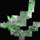
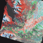
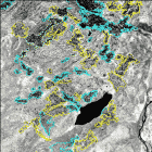
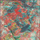
 |  | | Initial distribution range of polygons from ciprés de la cordillera forests on the study area. | Present distribution range of polygons from ciprés de la cordillera forests on the study area. |  |  | | A more detailed insight on the distribution of ciprés forests in 1970. | A more detailed insight on the current distribution of ciprés forests. |  Partners | 
